Chicago Tribune columnist Eric Zorn made a pitch in favor of gerrymandered legislative districts in a recent column, asserting that to reform Illinois’ district-drawing process while “red” states with Republican legislative control did not, amounted to “unilateral disarmament,” and would therefore be a mistake. And Zorn’s concerns are reasonable but place the wrong entities at the center of the districting process. A political party has no “right to maximize its seats” or even a “right to be treated fairly.”
It is the voter who have the right to representation, and to representatives who truly represent the interests of voters and their communities rather than pursuing the agenda of a given political party.
That should be obvious, shouldn’t it? We do not live in a country with a proportional representation method of allocating its legislative seats. Representatives represent voters directly, not through political parties. If we wished to have proportional representation, then, heck, the Democrats completely control the legislature and the governorship both; nothing would stop them from amending the Illinois constitution to implement this.
And, yes, voters are also represented by their specific legislators rather than by a caucus of legislators of their particular race/ethnicity. Again, if those in power believed that black voters and Hispanic voters’ interests were wholly defined by their black-ness and Hispanic-ness, respectively, well, then proportional representation would be the way to go for that, too. (Yes, I know there are federal and state voting rights laws at play here as well, but it remains troubling that the very notion of representative districts is so wholly demolished in the way this plays out.)
I say this because the Illinois Democrats have revealed their legislative districts for the Illinois House (official map here; link source here; existing map for comparison here). This is not the final map but potentially just the first part of a long process; if the Illinois legislature cannot finalize a map by June 30 of a post-census year, an eight-member bipartisan panel is selected, and if they cannot agree by July 10, a tie-breaking name is drawn from a hat. This procedure was intended to compel compromise, with each side being unwilling to leave the outcome to chance and settling on half a loaf, but, as the Trib reports, the tie-breaking procedure was used in 1971, 1981, and 1991. In 2001, “the legislature left the process to the state’s congressional delegation to draw a compromise map, which state lawmakers then approved,” and in 2011, the Democrats already controlled the legislature and the governor’s office, so they solidified that control with their remap. This year, the Republicans have staked their hopes on a legal challenge around the type of data being used, that would run out the clock on the legislative process that the Democrats would otherwise use to steamroll them, thus forcing the name-drawing. (Sorry, no link; I can’t find my source for this analysis any longer.)
There’s no analysis yet of what sort of partisan split this map will produce, that is, how lopsidedly in favor of Democrats this map would be but let’s look at it visually anyway:
Now, some of these districts don’t look thaaat bad: the ones in the southern half of the state I suppose they figure are mostly going to go to Republicans no matter what, so you might as well make them reasonably contiguous. At any rate, the 115th from the prior map looks like the sort that was drawn to exclude a particular established legislator:
In addition, in the towns to the east of St. Louis, there’s clearly some funny business going on, with a C-shaped district in purple and a green district within:
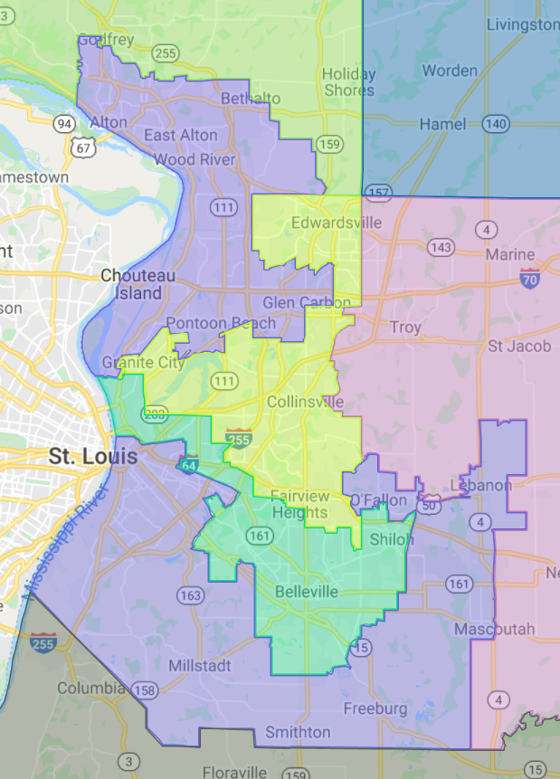
For what it’s worth, these districts mirror ones now existing (though they’re more extreme), and the carve out actually seems to be racial: the purple district aggregating the black voters for a black (Dem) representative in the 114th (plus enough leftover Republicans once this majority is ensured), with the green district collecting the leftover (white) Democratic voters. The current officeholder, Rep. LaToya Greenwood, won her race with a margin of 57% vs. 43%.
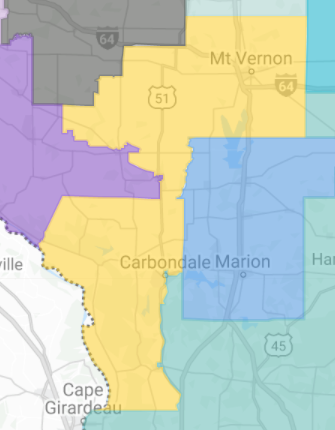
But moving northward: Springfield and Decatur are combined into a single, narrow district. Maybe that’s reasonable enough as Springfieldians and Decaturians might have more in common with their nearby hinterlands. But this district is even narrower now than before:
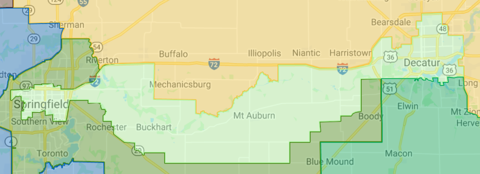
This district’s rep, Rep. Sue Scherer, won her 2020 race 51.5% to 44.4%. Was this too narrow a margin for comfort, motivating the Dems to shift more Dem voters into the district and shift Republicans out?
But that brings us to the greater Chicago area.
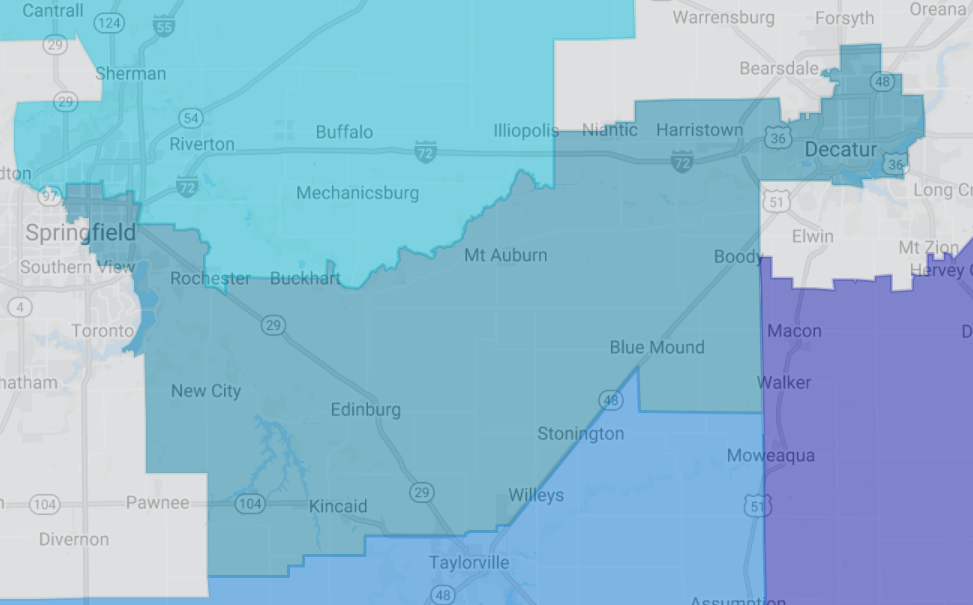
This J-shaped district? Dunno what the rhyme or reason is here. My best guess is that even though DeKalb and LaSalle/Peru are small towns, they are larger than their neighbors, and the algorithms said that another seat would be gained by combining them.

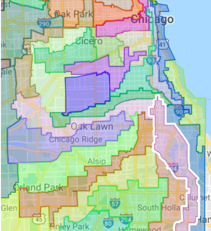
And finally, these creations on the south side of Chicago and the south suburbs:
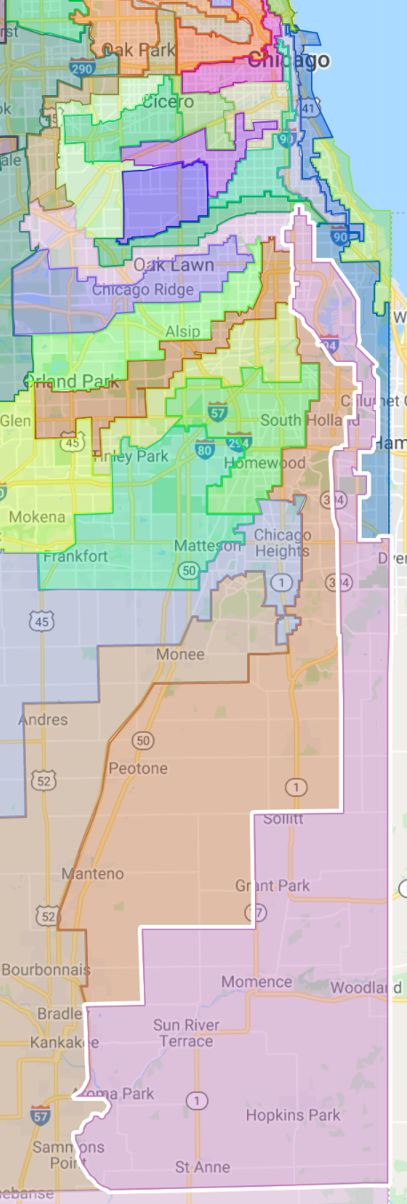
though, to be fair, there were many similarly bad long-and-narrow creations in the prior map, each of them creating districts of Democrats, and many seemingly designed to create districts “reserved” for black Democrats while tucking in white suburban voters who become a perpetual minority vote in their district as a result. And these narrow finger-districts are the most egregious of all, in so far as individual voters cannot reasonably have a connection to their legislator when there is no community being represented, no neighborhoods, when their neighbors, the folks with whom residents are connected with community organizations, churches, have no common legislator.
Finally, a group called CHANGE Illinois has been pushing for a “fair maps” reform and had previously pushed for a constitutional amendment.
But the Illinois constitution already says these districts must be “compact,” as well as contiguous and substantially equal in population (Article IV, Section 3). Yes, perhaps in the meantime courts have determined that “compact” is a meaningless word legally. But that still doesn’t make it right.
So, yes, there is nothing new under the sun. But Illinois politicians want Illinoisans to believe that they are reformed, that they are now ethically devoted to the common good, rather than in it for themselves. A map such as this, in which the people of Illinois simply, to such an astounding degree, do not have elected officials who represent them and their communities, means that no such claim is to be believed.
*Incidental footnote: How do the demographics of Illinois’ legislators compare to its population in general, in terms of racial/ethnic makeup? The most recent estimates are that Illinois is 61% non-Hispanic white, 15% black, 18% Hispanic, and 6% Asian. Among legislators, 71% are white, 18% are black, 8% are Hispanic, and 1% are Asian.
Are Hispanics unfairly underrepresented? A separate metric is the Citizen Voting-Age Population: here, 69% are white, 11% Hispanic, 15% black, and 4% Asian, and these percentages are much closer to the actual statistics. In any case, there have long been neighborhoods and towns which have a high enough black percentage that gerrymandering strategies can produce the desired result through their combining together of parts-of-town and the creation of multiple districts with “just-enough” desired voters to ensure the end result. But if new immigrants are coming to suburban apartment complexes spread throughout the area, there’s much less that can be achieved through these traditional gerrymandering methods. As the CVAP percentage of Hispanics grows, will Illinois look to other methods of determining who represents Illinoisans in the General Assembly, such as, in fact, a proportional representation system, or will they simply gerrymander ever more determinedly?